As we cross the Pattullo Bridge, we experience a kaleidoscope of sights, sounds and feelings when we think of Surrey's past and then view the Surrey of the present. Roads in those early days were not much more than hand-cut paths through forests with an occasional development along the way. These roads were eventually upgraded to allow for the increasing flow of traffic when the Pattullo Bridge was opened in 1937. The opening of King George Highway in 1940 was also advantageous for those making their homes in Surrey. Many arrivals were farmers from the Prairies. It is hard to imagine Surrey in those early days when the area was primarily farm land as we travel along the populated commercial corridor of the present King George Highway.
Near 108th, there still remain many old structures which were built around 1952 when there was a commercial and residential building boom after the tolls were removed from the bridge. As we travel up the hill towards 108th Avenue, we can see some of the 'old' Surrey on our left with the 'new' Surrey on our right with skytrains and highrises. The Dell Shopping Centre was opened in the 1950's and was considered to be a one-stop shopping centre at that time.
What was once called Surrey Place and is now known as Surrey Central was opened in the 1960's becoming the main shopping centre for all of Surrey. The land for Bear Creek Park was dedicated in 1931 as a park. At that time it was an undeveloped treed piece of land without the soccer fields, track, pool, children's playground or the railway that we know and enjoy today.
As we pass Queen Elizabeth High School which was opened in 1940, we again see the mix of old and new. The Dairy Queen across the street from the school is constantly filled with scantily-clad teenagers, a strong reminder of the many differences in life between 1940 and today.
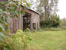
The Newton area grew more slowly because of the heavily timbered lands with mills being the main development in the area until land was cleared sufficiently to allow for further development. A small store eventually opened on the site where the Newton Fire Hall now stands. In 1925, Lew Jack, the owner of the store, built a home for his growing family which is now The Old Surrey Restaurant. While having dinner in this wonderful old building, one can almost hear the laughter of children bouncing from the walls.
After the Second World War, Newton began to see residential, commercial and industrial development as Surrey's popularity increased because of affordable housing when compared with Vancouver and New Westminster.
As one gets closer to 64th Avenue, commercial development thins with the area becoming more agricultural and residential. Crossing over #10 Highway and going down the hill, we are struck with the sharp contrast of flat agricultural land free of the heavy commercial development that one sees at the other end of King George Highway. Nurseries and blueberry farms, as well as a driving range, dot the landscape. Thirty-five percent of Surrey's land is currently designated agriculture with 2,300 hectares (5,400 acres) of park lands and green space available for residents and visitors to enjoy. Surrey, known as the "City of Parks", has more than 500 parks and greenbelts. Surrey has come a long way.
Subscribe to:
Post Comments (Atom)


No comments:
Post a Comment