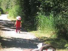
Burns Bog has a long history. During the 5,000 years the bog has been in existence, it has meant many different things to many different people. The bog is recognized as being globally unique because of its rare flora and fauna, natural habitat for the large variety of wildlife and for its unusually large land mass. It is located near the mouth of the Fraser River in lower British Columbia and is the largest raised bog on the west coast of North America and is also one of the largest in the world. It contributes to global biodiversity because of its storage of greenhouse gases, its importance as a nature reserve and as a wilderness area. Burns Bog has a story to tell.
In its early days, the First Nations People, comprised of the Tsawwassen, the Semiahmoo, the Katzie, the Musqueam, the Squamish and the Sto:lo Nations set up temporary villages in the bog during the summer months coinciding with the salmon runs. They hunted and gathered food using many of the unique plants in the bog for much of their necessary requirements.
Plants were used for medicinal purposes such as removing corns and warts; as good luck charms for fishing; for treatment of skin ailments and as a medicinal drink. Some of the leaves were dried to make a tea or used for ailments such as sore throats and colds. Some roots were used to make ropes while the bark of some trees were used for medicinal purposes. Other parts of plants were used for collecting marine shells which were traded or used as currency. Many of the forty species of peat moss (spagnum) were used as feminine hygience products, diapers and bedding. Many of the edible berries were harvested and dried to add to their winter food supply. The berries were an important source of their diet.
Burns Bog continues to remain an important aspect in First Nations mythology and also in terms of cultural, traditional and current uses. Burns Bog was controlled by the United States Army during World War II to use the peat moss to refine magnesium to be used for artillery shells. But it was never used for that purpose. Between the 1930's and 1984 a thriving business was conducted in the harvest of peat moss. This threatened the many beautiful and rare plants within the bog.
The Burns Bog Conservation Society, officially established in 1988, has been focused on protecting the Bog, fighting further development in order to preserve the ecological integrity of Burns Bog. The outside edges of the bog have already been disturbed with a landfill site, drainage ditches and adjacent blueberry farms. Even assuming there was no further disturbance to the bog, the damaged portion, due to its slow growth, would take 50 - 100 years to renew itself. Farming and other development is slowly eating away some of the areas of the bog so that intrusive non-native plants such as scotch broom and blackberry bushes are becoming a problem as they intrude into the bog. Visitors also, walking on other than designated trails, have further impacted the environment of the bog.
With development, greenhouse gases are released. Keeping the bog intact will slow the acceleration of global warming. Bogs are important because they filter the air and water, release oxygen, soak up potential flood waters and release nutrients into the river for the fish. The bog is known world-wide by environmentalists.
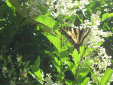
It is also home to more than 150 species of birds, insects, the rare Mariposa butterfly and a rare dragonfly. Many animals such as red fox, bobcat, beaver, porcupine, and blacktail deer inhabit the bog. It is also a habitat for many threatened and endangered species such as various Heron, the Trumpeter Swan, barn owls and the Greater Sandhill Crane. In First Nations mythology, it is said that the Sandhill Crane 'darkened the skies' with its great migratory numbers during their annual arrival to the Lower Mainland each spring. At last count there were between 9 and 11 of them.
Several major blazes have threatened Burns Bog in recent years. Because of the methane and rich peat, a fire can burn for months at a time. In 1996 Vancouver was covered in smoke and ash for two days, destroying 170 hectares. With each fire there has been substantial damage to the bog which will require many years to renew itself.
It is most people's belief that civilization should not be allowed to intrude on an area that offers so much to our community. On March 24, 2004, the government of British Columbia purchased 5,000 acres of Burns Bog. Hopefully this will ensure the preservation of flora and fauna dependent upon the bog for its survival and protect the numerous wildlife species whose home it is. The need to protect Burns Bog is still far from over.
Monday, April 27, 2009
Friday, April 24, 2009
The Ocean Park/Crescent Beach area of South Surrey
In this area. Surrey changes from the hustle and bustle of a busy city to an area of tranquility and peacefulness. Gone from sight and hearing are the thousands of cars, skytrain and buses. Gone also seems to be the stress and the apparent necessity to hurry.
Many of the original buildings in the area of Crescent Beach and Ocean Park still exist along with seemingly an aura of the past where conversations can readily begin with those unknown, smiles are an automatic response to those that hardly seem like strangers and friends are made from chance meetings. It seems to be a place where there is time to chat with a fellow shopper, a familiar face from the bus or another dog walker.
One of the old buildings still standing is what is now known as the Crescent Park Elementary School Annex which was the first school in the area built in the early 1900's. The Annex, tucked away on a cozy little lot situated amongst residential homes, is like a picture out of an old photo album. It still functions as a classroom for a small group of children from grades one to three. Many of these children's parents attended class in the same school, playing similar games in the largely unchanged playground. When talking to one lady, she said her son was going to the Annex, as had his father and grandfather. How many of us have that kind of continuity of history in our lives in a time when people tend to move so often?
Another older building is Crescent Park School which opened in 1948 to accommodate the increased student enrolment of the growing area. The original Ocean Park Hall was built in 1921 and what is now called the Ocean Park Hall was originally the post office.
In the early days Ocean Park was difficult to reach, as was Crescent Beach, being mainly accessible by the Great Northern Railroad. One train stopped each day and a second, if flagged, allowed vacationers to enjoy the quaint little seaside town of Crescent Beach. Those living in Ocean Park were required to make the hike from the station. But in spite of the difficulty of access, the community continued to thrive.
At Crescent Beach, a hotel once stood at the site of Beecher Place (where the public washrooms now are). When the hotel burned down in 1949, the lot remained empty until Beecher Place was built in 1982. In the early days of Crescent Beach, the hotel was the central hub of activity. The beach may not look very different from long ago with children laughing and playing in the water but the bathing suits are skimpier, the hairstyles have changed and conversation is probably very different. But the people are the same - they all come to Crescent Beach to have a good time - as they have always done.
Camp Alexandra was established in 1918 by the Alexandra Orphanage of Vancouver as a summer retreat for disadvantaged youth; they arrived on the Great Northern Railroad for their week at camp. Camp Alexandra is still there; the little cabins still exist. Inside the main entrance you will see old pictures of some of the former guests and employees of Camp Alexandra. Camp Alexandra continues to be a busy place.
In the early 1900's Crescent Beach was primarily a summer resort with few permanent residents. It is now a year-round residential community and many of the full-time residents were those whose families had originally had summer homes in those early days.
Tuesday, April 21, 2009
Surrey - Then and Now
As we cross the Pattullo Bridge, we experience a kaleidoscope of sights, sounds and feelings when we think of Surrey's past and then view the Surrey of the present. Roads in those early days were not much more than hand-cut paths through forests with an occasional development along the way. These roads were eventually upgraded to allow for the increasing flow of traffic when the Pattullo Bridge was opened in 1937. The opening of King George Highway in 1940 was also advantageous for those making their homes in Surrey. Many arrivals were farmers from the Prairies. It is hard to imagine Surrey in those early days when the area was primarily farm land as we travel along the populated commercial corridor of the present King George Highway.
Near 108th, there still remain many old structures which were built around 1952 when there was a commercial and residential building boom after the tolls were removed from the bridge. As we travel up the hill towards 108th Avenue, we can see some of the 'old' Surrey on our left with the 'new' Surrey on our right with skytrains and highrises. The Dell Shopping Centre was opened in the 1950's and was considered to be a one-stop shopping centre at that time.
What was once called Surrey Place and is now known as Surrey Central was opened in the 1960's becoming the main shopping centre for all of Surrey. The land for Bear Creek Park was dedicated in 1931 as a park. At that time it was an undeveloped treed piece of land without the soccer fields, track, pool, children's playground or the railway that we know and enjoy today.
As we pass Queen Elizabeth High School which was opened in 1940, we again see the mix of old and new. The Dairy Queen across the street from the school is constantly filled with scantily-clad teenagers, a strong reminder of the many differences in life between 1940 and today.
The Newton area grew more slowly because of the heavily timbered lands with mills being the main development in the area until land was cleared sufficiently to allow for further development. A small store eventually opened on the site where the Newton Fire Hall now stands. In 1925, Lew Jack, the owner of the store, built a home for his growing family which is now The Old Surrey Restaurant. While having dinner in this wonderful old building, one can almost hear the laughter of children bouncing from the walls.
After the Second World War, Newton began to see residential, commercial and industrial development as Surrey's popularity increased because of affordable housing when compared with Vancouver and New Westminster.
As one gets closer to 64th Avenue, commercial development thins with the area becoming more agricultural and residential. Crossing over #10 Highway and going down the hill, we are struck with the sharp contrast of flat agricultural land free of the heavy commercial development that one sees at the other end of King George Highway. Nurseries and blueberry farms, as well as a driving range, dot the landscape. Thirty-five percent of Surrey's land is currently designated agriculture with 2,300 hectares (5,400 acres) of park lands and green space available for residents and visitors to enjoy. Surrey, known as the "City of Parks", has more than 500 parks and greenbelts. Surrey has come a long way.
Sunday, April 19, 2009
The Barkerville of Then and Now
In the late 1850's prospectors followed the Fraser River to the creeks of the Cariboo in B.C.'s northern country as gold became more difficult to find in other areas. Billy Barker was one of those prospectors who decided to try his luck elsewhere. He formed the Barker Company along with seven other Englishmen. The area they chose to work was considered by most miners to be a poor choice but Billy and his group of men persevered. Surprising everyone, Billy and his group struck gold in 1862.
News of their gold strike spread and thousands of miners poured into the area. With their arrival, a town mushroomed like magic from the rocks and dirt surrounding their site. Saloons, dancehalls, general stores and boarding houses sprang up beside the wooden plank sidewalks and a new town was born.
Horse races and prize fights became part of life. The Hurdy Gurdy girls offered entertainment, charging the miners one dollar for every dance. Money flowed and prospectors paid for their whiskey with gold dust. As the town grew more and more women arrived in Barkerville.
Between 1862 and 1870, over one hundred thousand people had traveled the Cariboo Wagon Road to reach Barkerville hoping to find gold along the creeks that meandered through the Cariboo. After the road was completed in 1865, the well-known stage coach lines of Barnard Express traveled between Yale and Barkerville carrying miners and passengers to their destination.
The Chinese played a large part in the formation of the town and in helping with the construction and building of the Cariboo Wagon Road. It later became known as the 'Eighth Wonder of the World'.
At its height Barkerville was considered to be the largest city west of Chicago and north of San Francisco. Even during 1910 and the 1930's, the town managed to thrive until the 1940's when the new mining town of Wells came into being. Barkerville then became somewhat of a ghost town until 1957 when the provincial government began restoring the buildings.
The historic cemetery in Barkerville came into being when the first person was buried on the side of a hill on July 24, 1863. Peter Gibson was laid to rest at 31 years of age. On our visit to Barkerville, we walked through this interesting cemetery. After reading the tombstones, a visitor will note that the average age of those buried is about 32 years. This quaint cemetery is the last resting place of some of the great and not so great residents of Barkerville. We spent several interested hours exploring it and even the four year old we had in tow continued to be interested.
At present there are over one hundred buildings that are original to the town with about twenty reproductions. Unfortunately, we didn't go at the height of season when entertainment is in full swing but all 'residents' were in period costumes and we were able to enjoy a stagecoach ride. Our four year old was able to ride up top with the driver. That made his day. We panned for gold and saw how people used to live during that time period. Many of the shops feature Victorian-era merchandise. We also viewed displays, exhibits and demonstrations and some street entertainment. There are guided tours (which we didn't take) to Chinatown and the Theatre Royal.
Barkerville is the gateway to the past and thousands of visitors from around the world visit this historic town annually. In December for two weeks there are also old fashioned Christmas celebrations. To enjoy your visit to the past, I would recommend two days to see everything because, as we discovered, the visit to the cemetery alone will take several hours. Unfortunately, we had only planned for a one day visit which means we will be taking another trip sometime in the future. When visiting Barkerville, you can follow the route taken by miners in the Cariboo gold rush days so many years ago by following the old Gold Rush Trail along Highway 97 to Quesnel and then onto Highway 26.
Friday, April 17, 2009
I Don't Know Why I'm Always Surprised
Just a note to verbalize my displeasure and disappointment. We all know of the really despicable people in the world - murderers and those who harm children - who are at the very top of a long list of 'bad guys'. The list is long but at the bottom are the irritants and those, while not as bad as ones on the list further up, are less than respectable individuals.
I recently discovered that some of my articles that I have had published on line - and which are published on my blog http://www.progressofabraininjury.blogspot.com have been published by someone else with their name attached as the author. They have been published word-for-word from my own articles published on another article directory site. Some of the information in my articles was also in my published non-fiction book entitled 'Roller Coaster Ride With Brain Injury (For Loved Ones)'. To further prove that these articles are mine, my book can be purchased at: orders@trafford.com or by telephone at: 1-888-232-4444.
I'm not sure what can be done about individuals such as these. But I will look into it.
Wednesday, April 15, 2009
The Mighty Fraser River
The Fraser River is known as the largest, longest and the greatest salmon river in British Columbia. Beginning in Mount Robson Provincial Park, this sometimes beautiful and often turbulent river travels 1,375 km, ending in the Straight of Georgia.
The river's many rapids, tumbling through narrow canyons, are enjoyed by many whitewater enthusiasts every year. But the Fraser River is known predominantly as a working river. Ocean-going vessels constantly traverse the Fraser River from the Fraser River Port, at the mouth of the river to Fraser Surrey Docks, thirty km from downtown Vancouver.
Watching the river between these two ports is a vacation in itself and one that can be enjoyed all year long because of the temperate weather we experience in the lower mainland. No one can look at the Fraser River and be bored. Large and small tugboats work night and day towing barges of wood products, log booms, the occasional houseboat and often assisting the big ships as they travel up and down the river. Many of the large ships are sleek, conjuring up images of faraway places, while others look like the workboats they are. Larger fishing boats that fish the open sea and smaller ones who take their fish from the river travel back and forth; a steady procession reminding those who watch them of the importance of the river to those who live and work along its banks.
There is also a beauty to the Fraser River which changes constantly, much as the weather and light does. On an early summer morning, the turbulent river can be smooth, like a mirror, reflecting an image of the Alex Fraser Bridge and fluffy white clouds onto its surface, making it look more like a calm lake than the mighty Fraser it is. On an early morning in autumn, the picture can change when fog rises from the river and the Alex Fraser Bridge appears to be floating up through the mist, rising to greet another new day. And on a crisp winter's morning, the blue sky and shore side vegetation are reflected in the calmness of the river, a scene caught in the short space of time between the changing of the tide.
The wonders of nature can be enjoyed while watching the changes on this busy river, by glimpsing the occasional seal as he pops his head above the surface of the water and by watching eagles as they glide and soar above the water, occasionally swooping and returning from the river with a fish.
There are many areas along the Fraser where one can enjoy the river. Barnston Island, sitting in the middle of the Fraser, is such a place. A small agriculture island, it is reminiscent of a time gone by with flies buzzing lazily, dogs strolling companionably along the road and cows lifting their heads in greeting as you pass by. Also on a visit to the Quay in New Westminster, a visitor can stroll along the boardwalk while enjoying the view of the river as well as the beautiful gardens.
The Fraser River is many things to many people. It is a place to work; to play; to live; and to visit.
Monday, April 6, 2009
The Times They Are A Changing
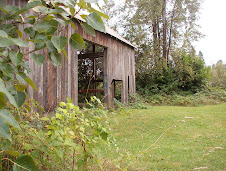
It was intriguing when we saw it; its rotten decking high above the level of the water. Once a busy wharf, it now jutted out into the water arrogant in its durability and importance, determined to withstand time. Like an elderly person it had retired from its original purpose and was now home to the grass and weeds that grew on its surface and the birds that made their nests in the long grasses.
Although its decking was rotten, the pilings were still strong and stable. It appeared to be happy with its existence. It showed a beauty that the elderly who know they have not outlived their time and use possess. Nor has this wharf yet outlived its time. I hope that man does not come along and decide otherwise.
Although its decking was rotten, the pilings were still strong and stable. It appeared to be happy with its existence. It showed a beauty that the elderly who know they have not outlived their time and use possess. Nor has this wharf yet outlived its time. I hope that man does not come along and decide otherwise.
Neglected and Forgotten
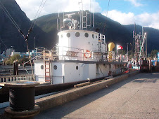
"Why?" I asked when I saw her lying amid tall grasses and wild saplings.
A boat is either a faithful employee as it searches the oceans for fish to sustain a fisherman's livelihood or a friend to spend time with, as laughing on the open waters, feeling the breeze upon our faces, she takes us where we wish to go.
Neglected, she now lies with her hull exposed, broken, unpainted and uncared for. She appears to have lain there for many years and is now beyond the point of repair. She died here but her remains have been left to rot, exposed to the harsh elements with no care for the loyalty of her youth.
Whether a faithful employee or as a good friend; both deserved better than this.
Sunday, April 5, 2009
The Old Red Bridge in Keromeos
The old covered bridge, although still the original, had recently received a new coat of bright red paint when we saw it in the spring. It was a disappointment because it no longer looked like the old bridge, comfortable and familiar in its faded and weathered exterior. Its new outfit of bright red did not look well on this one hundred plus year old bridge.
The Victoria, Vancouver and Eastern Railroad built the bridge in 1907 to help serve the various gold mines in the area. B.C.'s largest covered bridge crosses the Similkameen River and is only one of a handful of covered bridges in North America. The railway is no longer in existence and the bridge is now used as a highway to the south side of the Similkameen River and to Ashnola and Cathedral Lakes Park.
The Old Brown Bridge in Princeton
This historical bridge was originally built in 1886 as access from Princeton to Tulameen. It was later swept away in a flood before being replaced with a second bridge. It is unknown what happened to the second bridge but a third one was built in the 1930's. In the flood of 1958, this bridge also was almost swept away by an ice jam in the river but has remained steadfast ever since. It looks looks like an old bridge should look. If bridges are of interest, this one is worth visiting.
Saturday, April 4, 2009
Hidden Away In The Schuswaps
We came upon it quite by accident. The Malakwa Suspension Bridge spans the Eagle River, near Salmon Arm, which flows from the Schuwap Lake. Built in 1915, it allowed farmers to be connected to other farms in the area, to the community and the school system. It was rebuilt by the Ministry of Highways in 1940.
Simply built and looking old, I was leery about making those first tentative steps across its uneven surface. Cautiously I started along the rough boards; going only a few feet at a time I looked down at the beautiful emerald colours beneath me. As I slowly made my way across, I wondered about the many things this bridge had seen since its conception; the transportation of goods and friendly visits with neighbours. It was sturdily built and halfway across, I began to feel quite comfortable with my adventure although not as confident as I'm sure those early farmers had felt. This simple wooden bridge had opened up their world and expanded their opportunities. It had been a lifeline to them.
Other Old Bridges
The Old Alexandra Bridge in Yale, B.C.
Since the Cariboo Gold Rush Days in the 1860's, a bridge as spanned the Fraser River at the same location - 14 miles north of Yale on Highway 1 in the Fraser Canyon. The original, a suspension bridge was built in 1862. A second bridge was washed out in a flood in 1887. The replacement was built in 1925 and was used until 1965 when a new four lane bridge was built further downstream.
Walking across the bridge with open grid beneath my feet, I was a little disconcerted to see the Fraser rushing below me. Finally, after making it safely across to the other side, we discovered that the path no longer led anywhere.
Friday, April 3, 2009
Bays of Beauty - The Sunshine Coast
On a camping trip to the Sunshine Coast, we fell in love with the beauty of the shoreline in our explorations of Smuggler's Cove, Sargeant's Bay Provincial Park, Davis Bay, Pender Harbour, Sechelt, Gibsons and Roberts Creek.
As well as the natural beauty of the Coast, there is history that goes back to the early 1800's, hiking and biking trails, annual events, kayaking and a host of other enjoyable things to do. But the beauty of the Sunshine Coast was the loudest call of all.
Sargeant's Bay Provincial Park held a lot of interest for me in particular. Being a collector of driftwood, I thought I had reached 'driftwood heaven'. I spent enjoyable hours envisioning all my creations as I wandered this lovely beach.
The Pender Harbour area had us writing down the names of real estate agents. Pender Harbour was once the winter capital of the Coast Salish Nation and the Shishalh First Nations. Pender Harbour, from the early 1900's, has been a popular vacation spot because of its beauty and seclusion. We certainly found ourselves falling under the charm of the area.
Sechelt sits on a spit of land between Georgia Strait and Sechelt Inlet and is considered the Sunshine Coast's cultural capital. The town is home to artists and writers with many galleries, theatres and one-of-a-kind stores and restaurants. The Sechelt First Nation's Tems Awiya Museum chronicles the heritage of the Shishalh Nation displaying art, cedar carvings, artifacts and baskets.
Gibsons is the home of Molly's Reach, a set built for the old Beachcombers series. It is now a popular seafood restaurant. There are also many funky shops in Molly's Lane to visit. A point of interest is the historic Bonnybrook and Chaster Park area featuring a cairn noting the 1792 arrival of Captain George Vancouver. Visiting the harbour at Gibsons, we saw a sailboat decked out as an old pirate ship. There was also a garden flotilla (a houseboat with an unbelievable flower garden display).
Roberts Creek's Oceanside Regional Park and Roberts Creek Provincial Park are great for beachcombing and picnics. Trails weave through towering red cedars to add to your enjoyment of walking with nature by your side.
Because of the beauty of the many bays, it is easy to understand why kayaking is such a popular sport. The Sunshine Coast has unlimited shorelines with bays, inlets and offshore islands. While paddling the inlet, you will feel enveloped by nature as the coastal mountains surround you.
There is much to see and do; kayak the Sechelt Inlet, known as the Inland Sea. It is protected and excellent for the beginning paddler; attend the many events held annually on the Sunshine Coast; take walking excursions where you can explore the Sechelt marsh or walk to the Skookumchuck Narrows where tidal waters are forced through the narrows and into the Inland Sea. On a ten foot tide, 200 billion gallons of water churn through this narrow channel. If you are a true nature lover, take a trip to Porpoise Bay Park and enjoy the intertidal life. There are also numerous art galleries and museums. For more information on your visit to the Sunshine Coast, go to: www.bigpacific.com
Subscribe to:
Posts (Atom)